Projects
![]()
Taiwan
Debris Flow Hazards Mitigation in Taiwan
Chyan-Deng Jan
Director of the Disaster Prevention Research Center,
Professor of the Department of Hydraulic and Ocean Engineering,
National Cheng Kung University, Taiwan. Email: cdjan@mail.ncku.edu.tw
Abstract
As a result of heavy rains, steep topography, young and weak geological formations, strong earthquakes, loose soils, land development in mountainous terrain, many areas in Taiwan are susceptible to landslides and debris flows. Typhoons having the potential to carry heavy rains are among the most predominant hydrologic settings to trigger debris flows in Taiwan . This paper will introduce Taiwan 's geological and geomorphologic settings, debris flows caused by typhoons and the s trategies for debris-flow hazards prevention and mitigation in Taiwan .
Introduction
Taiwan is an island 36,000 km2 in size separated from the southeast coast of China by the 175-km-wide Taiwan Strait, as shown in Fig. 1. The island has an oval shape with a length of 394 km and a maximum width of 144 km. Taiwan Island was formed by the collision of an island arc with the Asian continental margin, and still has active process of mountain formation, resulting two-thirds its area covered by highly hilly mountains and hills, steep topography, young and weak geological formations, active earthquakes, and loose soils. The Central Mountain Range stretches along the entire island from north-northeast to south-southwest, forming a watershed divide separating rivers on the eastern and western sides of Taiwan. The Jade Mountain Range lies on the west side with Jade Mountain peak reaching 3,952 m elevation - the highest mountain peak in the Northeast Asia. Most mountains in Taiwan are very steep with slope gradients usually exceeding 25º and local relief of 1,000 m. Taiwans average elevation is 765 m, with about 31 % of the total island area exceeding 1,000 m in elevation (Jan and Chen, 2004).
Significant denudation results from landslides, debris flows, and soil erosion in mountainous terrain. Landslides generate a large amount of loose, weathered materials, which are delivered to creeks, thus forming the dominant sediment supply mechanism for debris-flow-prone channels. Several investigations of landslides in the mountains of the central and eastern parts of Taiwan have revealed a spatial density of 0.27 landslides/km2 and a landslide area ratio equal to 0.84 %. Landslide causes include weak rock and rapid weathering, while landslide triggers include runoff concentration, undercutting by streams, and road construction. About 60 % of landslides are susceptible to reactivation. The average denudation rate of the Central Mountain Range of Taiwan is about 14 kg/m2/yr, which is equivalent to 5.5 mm/yr if the density of rock is assumed to be about 2.5 g/cm3 (Dadson et al., 2003). Tectonic activity and associated vigorous denudation supply material to hillslopes and stream channels, thus affecting the frequency and magnitude of debris flows (Jan and Chen, 2004).
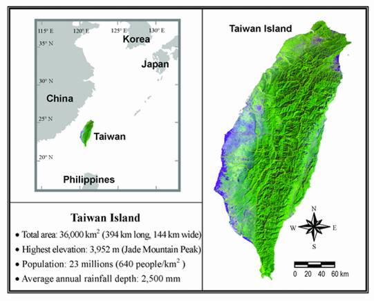
Fig. 1. Location of Taiwan having many areas susceptible to landslides and debris flows.
(after Jan and Chen, 2004)
Debris Flows Caused by Typhoons
Taiwan has mild weather throughout the year except during a typhoon. Typhoons are most frequent from July to October. They usually begin in low latitudes in the North Pacific Ocean near the Philippine Islands, move north or northwest, and then pass through the Taiwan Island or turn northeast at high latitudes towards Korea or Japan. The violent winds within a typhoon can cause great destruction, resulting in the loss of life and property due to high winds, suddenly rising waves, and heavy rains. On average, three typhoons hit Taiwan annually. The amount of rainfall received on Taiwan during the passage of a typhoon is dependent on the speed, size, and intensity of the rain-producing center of a typhoon and on the topography of the land swept over, thus varying spatially and concentrating on the mountainous interior of Taiwan. Taiwan receives an annual rainfall of 2,500 mm, with maxima exceeding 5,000 mm in some high mountain regions. About 80 % of annual rains fall from May to October, especially during typhoons. Rainfall intensity during some destructive typhoons may exceed 100 mm/hr and 1,000 mm/24 hr. The recorded maximum one-hour and 24-hour rainfalls before 1996 were 300 mm and 1,672 mm, respectively. The recorded 24-hour rainfall was broken by the heavy rain accompanying Typhoon Herb and reached 1,749 mm, as shown in Fig. 2 (Jan and Chen, 2004).
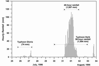
Fig. 2 Temporal rainfall variation during Typhoon Herb, 1996 (after Jan and Chen, 2004) .
As a result of heavy rains accompanying typhoons, steep topography, young and weak geological formations, strong earthquakes (25 earthquakes of magnitudes larger than 6 on the Richter scale in the 20th century), loose soils, land development in mountainous terrain, many areas in Taiwan are susceptible to landsliding. Among so many causes, typhoons are especially important agents of debris flows in Taiwan. One of the first well documented debris-flow catastrophes occurred on June 23, 1990 in Tongmen village, located in the west of Hualien City on the east coast of Taiwan, during Typhoon Ofelia, with rainfall intensities exceeding 106 mm/hr. This debris flow (with estimated volume of 56,000 m3 and average speed of 8.4 m/s), killed 35 people and destroyed 24 houses. Since this event, the number of debris flows in Taiwan has increased. On July 31, 1996, Typhoon Herb struck Taiwan, and caused severe 52 debris flows, 47 of which occurred in the Chenyoulan stream and its tributaries in Central Taiwan (Jan and Chen, 2004; Yu, 1997). There were 73 people killed by Typhoon Herb in Taiwan.
After Typhoon Herb, a large disastrous earthquake of 7.3 on Richard scale took place at Chi-Chi in Central Taiwan on November 21, 1999, and has contributed to about 3,000 people killed as well as to tremendous amount of loose earth and stones accumulated on the surface of the slopes or between the valleys, especially in the mountainous area of Central Taiwan. Tremendous amount of loose earth and stones due to the big earthquake not only increase the possibility of debris flows and landslides, but also deteriorates the problem even worse.
For example, in July 2001, Typhoon Toraji struck Taiwan with a heavy rainstorm (Fig. 3), killed 214 people and induced numerous debris flows/landslies in various gullies in the Chenyulan stream watershed. In 2004, Typhoon Mindulle landed on Hulien County, Eastern Taiwan on July 1, and then passing through the northern Taiwan on the morning of July 2. Even though, Typhoon Mindulle did brought some heavy rains in the eastern and southern parts of Taiwan during it was moving through Taiwan from July 1-2, but did not cause severe damages. However, much more heavier torrential rains fell on Taiwan between July 2 to 4 after Typhoon Mindulle left from Taiwan, especially on the central and southern Taiwan. More than 40 Climate Stations in Taiwan recorded the three-day accumulated rains (July 2 to 4) exceeding 1,000 mm. The three-day rains measured at the Hsinan Climate Station in Kaohsiung County, Southern Taiwan, exceeded 2,000 mm. The severe rains caused numerous flooding, landslides and debris flows. Most debris flows occurred in Taichung County and Nantou County in Central Taiwan. The severest debris flows occurred at Songhe, Taichung County. About 40 houses were buried or severe damaged by the debris flows (Fig. 4), but fortunately, only two people were killed by the debris flows. In the Typhoon Mindulle event, totally, there were 41 people killed, mainly caused by flooding, instead of by debris flows, because the rainfall-based debris-flow warning did a well job and the evacuation of people in the debris-flow-prone areas was well implemented (Jan and Lee, 2004).
Table 1. Five significant typhoons landing on Taiwan in the last decade.
| Typhoons' Name | Year | Date | Max. one-hour rainfall (mm) | Total rainfall (mm) | No. of people killed | No. of debris flow induced |
| Herb | 1996 | July 31-Aug. 1 | 112 | 1994 | 73 | 52 |
| Toraji | 2001 | July 29-30 | 147 | 757 | 214 | 192 |
| Nari | 2001 | September 17-19 | 142 | 1462 | 104 | |
| Midulle | 2004 | July 1-4 | 167 | 2143 | 41 | 135 |
| Aere | 2004 | August 23-26 | 146 | 1535 | - | - |
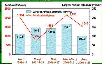
Fig. 3 Maximum hourly rainfall and total rainfall in five typhoon events

Fig. 4. Debris flows occurred at Songhe, Taichung County, caused by Typhoon Mindulle in July 3, 2004. About 40 houses were buried or severe damaged by the debris flows, but fortunately, only two people were killed by the debris flows due to successful warning and evacuation.
Debris-Flow Mitigation Strategies in Taiwan
The central government in Taiwan, such as the Council of Agriculture (COA) and the National Science Council (NSC), has a leading role in sponsoring debris-flow research and developing a comprehensive program for the mitigation of debris-flow hazards. More scientists have been engaged in debris-flow research after the Typhoon Herb event. Being in charge of the central control (e.g., prevention, mitigation, emergency management and evacuation, and rescue operation) of debris-flow hazards in Taiwan, the COA has developed debris-flow hazards mitigation strategies and measures, such as structural and non-structural countermeasures. The Soil and Water Conservation Bureau (SWCB) of the COA is responsible for all debris-flow related engineering projects. The structural countermeasures include the installation of debris barriers, debris breakers, debris basins, deflection berms, slit dams, check dams, and/or Sabo dams in debris-flow gullies and alluvial fans.
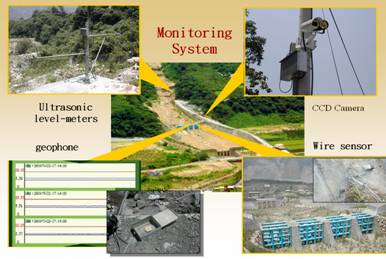
Fig. 5 Debris flow warning and monitoring system at Fengqiu in the Chenyoulan stream watershed.
Rainfall-Based Debris-Flow Warning System
In addition to such debris-flow controlling structures, the countermeasures in this context may embrace the installation of rainfall-based warning/monitoring systems and instrument-operated warning systems. About 30 rainfall-based warning/monitoring systems have been installed since 1992. Each monitoring station consists of a rain gauge, a geophone, and a video camera. Some new monitoring stations set up after 2002 have been equipped with a rain gauge, ultrasonic airborne level-meters, geophones, wire sensors, infrared Charge-Coupled-Device (CCD) cameras, and a satellite communication system to transmit electronically measured data to the Debris Flow Emergency Operation Center of the SWCB. These data can be analyzed and the results can be used in making decisions on how to mitigate debris-flow hazards. The rainfall-based debris-flow warning model has been developed in Taiwan, as shown in Fig. 6.
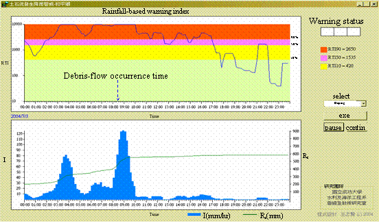
Fig. 6. Temporal variations of the rainfall intensity, the effective accumulated rainfall, the rainfall triggering index (RTI) and its corresponding debris-flow occurrence probability at Heping, Taichung County on July 3, 2004. RTI is the product of the one-hour rainfall and the accumulated rainfall. The higher RTI-values the higher potential of debris-flow occurrence. The critical values of RTI for high debris-flow occurrence and for low debris-flow occurrence at Heping are 2650 and 420, respectively.
To establish a database, the COA has commissioned the National Cheng Kung University (NCKU) to investigate the zoning of potential debris-flow hazard areas as well as to identify sites of high debris-flow risk since 1990. The regional and local governments are committed to alert the inhabitants residing in the vicinity of potential debris-flow hazard areas for evacuation when a debris flow occurs. Since 1996, NCKU mapped 485 highly hazardous debris-flow-prone streams based on geomorphologic characteristics and consequences (loss of life, property and infrastructure) (Shieh, 1997). The number of hazardous debris-flow-prone streams has increased to 1,420 following the 1999 earthquake, according to the field investigations conducted by NCKU in 2001 and 2002. The NCKU was further commissioned to implement the zoning and aerial photography of the potential hazard areas along the 1,420 debris-flow-prone streams. In order to enhance public safety and awareness, the COA has installed debris-flow warning signs at the crossing of roads and all the debris-flow-prone streams.
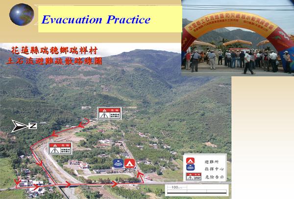
Fig. 7 Evacuation planning and practice for debris-flow hazards prevention
Conclusion
As a result of heavy rains, steep topography, young and weak geological formations, strong earthquakes, loose soils, land development in mountainous terrain, many areas in Taiwan are susceptible to landslides and debris flows. Typhoons having the potential to carry heavy rains are among the most predominant hydrologic settings to trigger debris flows in Taiwan. To avoid culvert and bridge blockage or destruction by debris flows, the design codes of culverts and bridges in mountainous areas have been upgraded. Nowadays, for bridge and culvert design, the design considers floods with a recurrence interval of 50 years rather than the previous standard of 25 years. The central government in Taiwan has realized that it is impractical, if not impossible, to completely prevent debris flows. Except traditional structure countermeasures against debris flow hazards, many mountainous villages have conducted debris-flow disaster prevention and evacuation practices to enhance inhabitants hazard-mitigation knowledge and emergency-response swiftness as well as their familiarity with evacuation routes and shelters (Fig. 7) under the sponsorship of the COA or the SWCB of the COA in Taiwan. The SWCB of the COA also provides the state of art of the knowledge of debris flow and its countermeasures through his web site: http://fema.swcb.gov.tw. The next big debris-flow catastrophe will undoubtedly occur somewhere on the planet, and perhaps the experience of debris-flow mitigation strategies in Taiwan will help to soften the consequences, and reduce future losses.
- Acknowledgement
The financial supports on debris-flow researches from the National Science Council (NSC) and the Soil and Water Conservation Bureau (SWCB) in Taiwan are acknowledged.
References
- Jan, C. D. and Lee, M. H. (2004), A Debris-Flow Rainfall-Based Warning Model. Journal of Chinese Soil and Water Conservation, Vol. 35(3), pp. 273-283. (in Chinese)
- Jan, C. D., and Chen, C. L. (2005), Debris Flows Caused by Typhoon Herb in Taiwan. Chapter 21 in Debris-Fow Hazards and Related Phenomena, edited by M. Jakob and O. Hungr. Praxis Publishing in England.
- Dadson, S. J., Hovius, N., Chen, H., Dade, W. B., Hsieh, M. L., Sillett, S. D., Hu, J. C., Horng, M. J., Chen, M. C., Stark, C. P., Lague, D. and Lin, J. C. (2003) Links between erosion, runoff variability and seismicity in the Taiwan orogen. Nature 426, 648-651.
- Shieh, C. L. (1996) High potential creeks of debris flow and landslide in Taiwan. Report for the Council of Agriculture, Taiwan (in Chinese).
- Soil and Water Conservation Bureau in Taiwan (2004), http://fema.swcb.gov.tw.
- Yu, F. C. (1997) Case studies of debris flows caused by Typhoon Herb. Journal of Modern Construction 209, 9-19 (in Chinese).
(Quotation literature: International Symposium on Utilization of Disaster Information~Organizing and Sharing Disaster Information in Asian Country~(JSECE Publication No.44), Copyright © The Japan Society of Erosion Control Engineering)