Projects
![]()
France
History of RTM (Restauration des Terrains en Montagne) Projects in France
Takao Yamakoshi
Senior researcher
Volcano and Debris Flow Team, Erosion and Sediment
Control Research Group, Public Works Research Institute
1. Introduction
France is blessed with flat ground suited for habitation with a national land of 550,000 km2, about 1.5 times as large as Japans, of which about 2/3 are flatlands. At the same time, the country has the Alps, which includes Western Europes highest summit Mont Blanc (4,807 m above sea level) and the Jura Mountains in the eastern part and the Massif Central and the Pyrenees in the southwestern part. These mountainous areas are also inhabited by many people and recently accepting many visitors as skiing and mountain sightseeing become more and more popular. As with other countries surrounded by the Alps such as Austria and Switzerland, France has a history of sediment control projects for restoring devastated mountains and preventing sediment-related disasters. In France, such a project is called RTM (restauration des terrains en montagne), which corresponds to sabo and chisan (erosion control and forest conservation) in Japan. This report outlines the history of RTM projects in France mainly based on the overview by Gérard Brugnot and Yves Cassayre (2002)1). Section 2 below is an abridged version of its translation. The original does not contain the figures shown here, which have been added by the author of this report based on his independent judgment.
2. History of RTM projects in France
2.1 From deforestation to mountain restoration
As was the case with many other countries, active deforestation took place in France until the end of the 18th century for timber for fuel and shipbuilding. In addition, the belief in those days that the cooling in the medieval times currently known as the Little Ice Age was caused by the adverse effect of forests that cooled the climate accelerated deforestation.
In the 19th century, calls for the need of mountain restoration became louder little by little in France. Some insightful people started to publish books describing the link between deforestation, mountain erosion and flooding of rivers, which helped gradually spread awareness of human-induced deforestation as a cause of mountain destruction providing the major source of disasters.2) In 1841, Alexandre Surell wrote a book entitled Etude sur les torrents des Hautes-Alpes, which is considered the first compilation of erosion prevention techniques and contributed to the forming of the technical basis required for mountain restoration.
In such circumstances, laws to prohibit deforestation and promote reforestation started to be discussed in the parliament, which met strong opposition from farmers and stockbreeders because expropriation of land and a ban on deforestation would affect their livelihoods in the mountains. This led to the withdrawal in 1847 of the bill for promoting RTM projects.
In the 1850s, however, most of the major rivers in France experienced extensive floods with the 100-year recurrence period which caused enormous damage. As a result, the public opinion that the devastation of the mountains at the riverheads should not be left unattended became stronger and a law concerning mountain restoration was passed in 1860 against the opposition from the people living in the mountains (no existent photos of disasters in the 1850s are available to the best of the authors knowledge and photos taken a little later in the 1880s (Figures 1 and 2) are presented here, which should help gain an understanding of the facts described in this report).
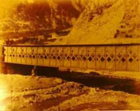
Figure 1: Iron bridge at the base of Mt. Cenis in the Rhone region3)
Aggradation of the riverbed after the construction of the bank left little clearance. Dated September 1886.

Figure 2: Raised-bed river near St. Jean Village in Maurienne3)
Riverbed is 5-6 m higher than the ground. Dated August 1887.
2.2 Enactment of laws concerning mountain restoration and the prosperity of RTM projects
The law made in 1860 encouraged forestation in any event. The government expropriated devastated mountains and started to plant trees.
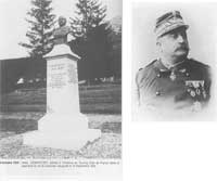
Figure 3: Prosper Demontzey (1831-1898)
Called the father of RTM in France, Demontzey is known as a person who pressed on with RTM projects.
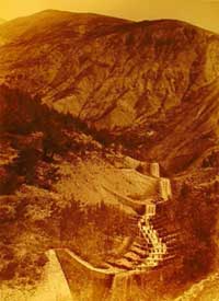
Figure 4: Dyke on Torrent of Bourget (on Ubaye River, Alpes-de-Haute-Provence)4) (Undated; presumed to be taken before 1887 since the photo is contained in an album made in the year.)
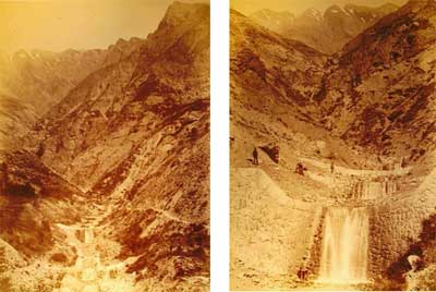
Figure 5: Dyke on Torrent of Saniere (on Ubaye River, Alpes-de-Haute-Provence)4)
(Undated; presumed to be taken before 1887 since the photo is contained in an album made in the year.)
Projects under this law faced fierce resistance from mountain residents. In addition, forestation proved not to be a cure-all medicine when disasters occurred on scales that overwhelmed forestation, which fueled the resistance.
Meanwhile, the considerable cost required for the forestation of large areas led to the enactment of a new law in 1864 for the restoration of vegetations first rather than forests: Law for Replanting of Grass in Mountainous Areas. The restoration of vegetations targeted by this law benefited stockbreeders and the legislation achieved a certain effect.
In 1882, the Law on the Restoration and Conservation of Alpine Lands was enacted. This law got Frances RTM projects off the ground for the first time. Under the law, the target areas of RTM were designated by the government, in which the government was allowed to reforest and build civil engineering structures. The grounds for the designation of target areas were also clearly stated in the law. Technically, the project that focused only on plantation until then came to incorporate civil engineering structures after the enforcement of the law based on the theories that had been studied by engineers, which marked a great stride.
Subsequently, RTM went through a golden age between 1882 and 1914 when most of the works in the mountain restoration projects in France were carried out. Many big named dedicated to the development of mountain restoration projects of France also appeared in this period, one of whom is Demontzey, nicknamed a trainer of mountain streams (Figure 3).
The extensive development of the projects resulted in the creation of employment in mountainous areas, which eased the conflict with the mountain residents and contributed to the progress of the projects.
In this period, measures were taken for 1,100 torrents, 100 avalanches and over 100 landslides. Moreover, forestation efforts continued even though the law enacted in 1860 had been abolished and 177 target areas of RTM were designated reaching a total area of 3,000 km2, of which 2,150 km2 had forestation completed by 1909 (Figures 4 and 5).
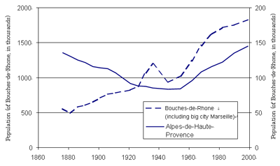
Figure 6: Changes in populations in Bouches-de-Rhone and Alpes-de-Haute-Provence5)
The graph shows that, after 1860, the population of Bouches-de-Rhone, which has Frances second largest city Marseille, has constantly increased except for the temporary decrease due to World War II, while in Alpes-de-Haute-Provence, where RTM projects were intensively implemented, the population steadily decreased until around 1960.
2.3 Stagnation in RTM projects
After World War I, the RTM projects ran out of steam in France along with other Alpine countries. The mountain population had already been decreasing since the late 19th century and the war accelerated the downward trend (Figure 6).
Although population decrease in mountainous areas had an effect of weakening the opposition to the projects at the beginning of the 19th century, further population decrease because of World War I undermined momentum of RTM projects. After this period, most of the funds for RTM projects were allocated to the maintenance of the existing target areas of RTM. After 1943, no new target area has been designated and World War II dictated the trend. Workers no longer accepted jobs in the same conditions as the beginning of the 20th century and the dramatic increase in the costs of works affected the project expenses.
At the same time, fundamental changes occurred in land utilization patterns in the mountains. As a result of the development of mountain sightseeing and the railroad systems in mountainous areas, people with little knowledge about mountain environment (tourists, etc.) came to flock to the mountain regions, which generated new vulnerabilities to sediment-related disasters.
One avalanche occurred in a place called Val dIsère in Rhone-Alpes caused 39 deaths (Figure 7). In response to this great damage, the public opinion heated up and raised the risk of avalanche to a national priority issue to be resolved. The voice drove the government at that time towards swift implementation of measures firmly intended for the protection of human life rather than the traditional RTM projects based on large-scale construction works that might stretch over years. Specifically, the awarness became stronger of the importance of creating hazard maps and developing weather warning systems. In line with such a trend, a policy to announce risks came into being under the initiative of a famous volcanologist Haroun Tazieff at the beginning of the 1980s.
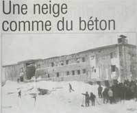
Figure 7: Photo of an avalanche disaster in Val dIsère A snow like concrete (from the Dauphiné Libéré dated February 11, 1970): At about 8:00 am on February 10, 1970, a massive avalanche that occurred at an altitude of 3206 m ran over Isère River to reach the national road and went on to the UCPA, outdoor boarding facilities of France. This avalanche claimed the lives of 39 people including trainees who were staying there.
2.4 Reconstruction of the service RTM
In this new trend, the service RTM was reconstructed in 1980. The new agency maintained the previous name and organizationally continued to be positioned under the Office National des Forêts, an external organ of the Ministère de l'Agriculture, but the nature of the projects implemented changed significantly. The area of its jurisdiction was limited to 10 (later 11) departments located in high mountainous regions, which are the departments adjacent to the Alps or the Pyrenees (Figure 8). Meanwhile the Service de RTM started to work on the project for the protection of lives and properties, or the creation of danger area maps (Figure 9). This project is carried out as a commission received from departments and the proportion of this project out of all of the operations implemented by the Service de RTM is increasing over time.
3. Conclusion
In Austria, which is well-known by us Japanese as an advanced country in sabo technology, the massive flood disaster that occurred in the territory of then Austria-Hungary in 1882 led to the initiative for sediment control and forest conservation as a national undertaking that started in 1884.7) In France, on the other hand, large-scale flood disasters that frequently hit the country in 1850s provided a momentum to establish a relevant law in 1860 and an undertaking was officially launched. France had a history of sediment control that started as an enterprise of national importance earlier than Austria.
Why did sediment control projects start at a national level in France ahead of Austria? As mentioned earlier, it may not be only because the disasters that urged measures took place earlier but also many other factors in the background are involved. However, the author still does not have enough knowledge for observation with the social situations in Europe in the 19th century taken into consideration and is unable to readily discuss the subject here. Nevertheless, the history of RTM projects of France is obviously affected by the dramatic changes in the social situations of the country, as described in Section 2. France seems to be an ideal subject of research when studying sediment control projects from a sociological point of view.
The total population of the 11 departments in which RTM projects are carried out is 5.77 million, which means that a population comparable to that of Austria (8.1 million) or Switzerland (7.3 million) lives in mountainous areas. The importance of sediment projects in France does not rank much lower than in Austria or Switzerland.
There seems to have been a period of exchange between Japan and France in the past as characterized by the visits for study by Nobuo Ikeda, an engineer of the Interior Ministry who designed a French-style stepped channel in Ushibuse River, and Takeo Ito, who later became a professor of sediment control engineering at the University of Tokyo. However, sediment control in France has seldom been mentioned in recent years. The reason for this may be that France rarely participates in conferences such as Interpraevent or International Sabo Symposium but France certainly is carrying out sediment control projects, of which only a few are mentioned in this report.
The main topic of this report has been the history of sediment control in France. The author looks forward to the next opportunity to offer more information about sediment control and forest conservation projects in France and the current situations of research and development.
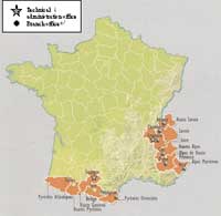
Figure 8: Current distribution map of RTM project regions
The RTM administration office is in Grenoble.
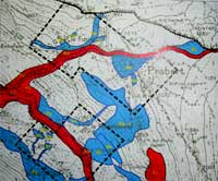
Figure 9: Danger areas based on the Plans for the Prevention of Predictable Natural Disasters (Plans de prévention des risques naturels prévisibles)6)
Construction works, etc. are prohibited in areas marked in red and allowed with conditions in areas marked in blue. The creation of natural disaster prevention plans was made compulsory by the law established in 1995. For areas that may be affected by natural disasters, danger area maps are created as shown in this figure for imposing restrictions on the land use, etc.
Acknowledgments
The author acknowledges with gratitude the contributions of Dr. Didier Richard, Dr. Nicole Mathys and Dr. Freddy Rey of CEMAGREF of France, who offered various tips that helped make this study possible.
References cited
1) Gérard Brugnot and Yves Cassayre (2002): De la politique française de restauration des terrains en montagne à la prévention des risques naturels, Actes du colloque Les pourvoirs publics face aux risques naturels dans lhistoire, Grenoble, March 2001, La MSH Alpes, 11p.
2) Vallauri, D. (1998): Relecture par un écologue des principaux écrits sur la restauration des éspaces érodés dans les Alpes du Sud (1797-1994), Revue Forestière Française, no.4, p. 367-378.
3) RTM (1887): VUES PHOTOGRAPHIQUES, SAVOIE PÉRIMÈTRE DE LARC SUPÉRIEUR (MAURIENNE), 50p.
4) RTM (1887): VUES PHOTOGRAPHIQUES, BASSE-ALPES PÉRIMÈTRE DE LUBAYE, 40p.
5) INSEE (1999): RECENSEMENT DE LA POPULATION, MARS 1999,
http://www.recensement.insee.fr/RP99/rp99/page_accueil.paccueil
6) Ministére de lAménagement du Territoire et de lEnvironnement and Ministére de lÉquipement, des Transports et du Logement (1999): Guide Général, Plans de prévention des risques naturels prévisibles (PPR), La Documentation française, 76p.
7) Jörg Heumader (2005):Schutz vor Wildbächen in Tirol, Oesterreich (Protection of Wildwaters in Tirol, Austria), Journal of the Japan Society of Erosion Control Engineering Vol.57 No.6 pp.76-79.