| Name/Title | The 2011 Typhoon Committee Integrated Workshop |
|---|---|
| Venue: Country,City | Nha Trang, Vietnam |
| Date | Nov. 7to11, 2011 |
| Detail |
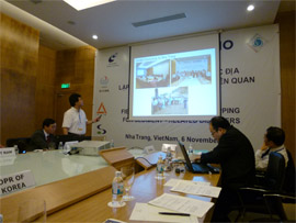
The 2011 Typhoon Committee Integrated Workshop (Nha Trang, Vietnam)The Typhoon Committee Integrated Workshop was held in the city of Nha Trang, located in the southern region of Vietnam from November 7 to 11, 2011. Ahead of this, the workshop of the Landslide Hazard Mapping Project was held on November 6. Ahead of the International Workshop, an in-class lecture on hazard mapping and field training for actually observing streams and debris-flow torrent were held as the SABO Workshop on November 6. A total of twenty people from six countries (Vietnam, mainland China, Japan, South Korea, Laos, and Thailand) participated in the Erosion Control Workshop. The in-class lecture was held in the Michelia Hotel, the site of the Integrated Workshop, on the morning of November 6. Researcher Hayashi from the National Institute for Land and Infrastructure Management (NILIM) of Japan explained the meaning of implementing hazard prevention work without building facilities, methods of designating sediment-related disaster warning areas under the Sediment-related Disasters Prevention Law in Japan, and necessary actions to activate warning and evacuation systems, for related organizations and residents. The participants had a field training by a river near Nha Trang in the afternoon. A stream with a granite distribution and a catchment area of about 2.0 km2 was selected for this field training. According to interviews with residents who had recently moved to this area, river bank erosion has destroyed parts of their gardens but caused no damage to humans or houses. This stream could cause big damage depending on heavy rain. It is anticipated that the participants got a greater awareness of hazards by observing high-risk areas.  The International Workshop was held from November 7 to 11. The participants separated into different working groups (Hydrology, Meteorology, and Disaster Risk Reduction) from the afternoon of November 7 to November 9, and parallel meetings were held to share information on the progress of individual projects within the working groups and coordinate future plans and budgets. Mr. Kondo, from Sabo and Landslide Technical Center, Japan, reported the progress of a sediment-related disaster hazard mapping project, the implementation of SABO Workshops, and case studies at model basins in different countries in the parallel meeting of the hydrology meeting. Mr. Hayashi, the researcher of NILIM, Japan, explained plans for the next year and requested a budget.  Researcher Hayashi proposed the Establishment of Warning and Evacuation System against sediment-related disasters Project as a project to take over from the sediment-related disaster Hazard Mapping Project which ends next year. The proposed project incorporates the results of the sediment-related Disaster Forecasting warning System Project (project leader: Dr. Hideaki Mizuno, chief researcher of NILIM) and the Hazard Mapping Project that is now being implemented. The project conducts investigations in different countries, identifies points to be improved in those countries, and explores solutions concerning aspects that relevant organizations and residents should implement to ensure the effective functioning of warning and evacuation systems. Participants from Thailand, where huge floods had been causing serious damage since the beginning of October 2011, also reported on the conditions of the flooding and provided opportunities for the participants to gain valuable information. |