Projects
![]()
Survey Report on Sediment-related Disasters in Sri Lanka
Junichi Kurihara
Senior Researcher, Volcano and Debris Flow Team
Erosion and Sediment Control Research Group, Public Work Research Institute
1. Introduction
It is still vivid in our memories that the coastal region of the Democratic Socialist Republic of Sri Lanka sustained devastating damage when a massive Indian Ocean tsunami struck the region in December 2004. However, it is relatively unknown that this region which belongs to a tropical monsoon climate zone has been involved in numerous sediment-related disasters due to monsoon rainfall. As a recent case, a major sediment-related disaster and flooding occurred in the southern part of the country in 2003, killing 300 people and affecting 120,000 as a result of the worst rainfall in 50 years which hit the region on May 17 and 18. 1)
Recently, I had an opportunity to make a field survey on the status of sediment-related disasters in Sri Lanka as part of a development survey program of Japan International Cooperation Agency (JICA). The results of this survey are presented in this report.
2. Actual state of sediment-related disasters
(1) Major sediment-related disasters in the past
In Sri Lanka, the National Building Research Organization (NBRO) is responsible for the research of sediment-related disasters. Figure.1 is a map prepared by NBRO showing the locations of sediment related disasters that occurred in this country from 1947 to 2003. It is seen that most of the disasters occurred in the mountainous areas in the southwestern part of the island. The current field survey was conducted in the Ratnapura area which is frequented with sediment-related disasters. The annual rainfall at Colombo is about 2,300mm and the characteristic is that the rainfall amount is particularly large in May and October (Fig.2). Photo.1 shows a landslide that occurred in Nuwara Eliya in 1992. A railway freight car fallen into the landslide is seen. From this photo, it seems that the depth of the collapse was as large as 5 m.
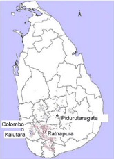
Fig.1 Locations of sediment-related disasters in 1947-2003
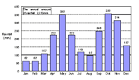
Fig.2 Monthly mean rainfall in Colombo
(1971-2000 HP of Department of Meteorology, Sri Lanka)
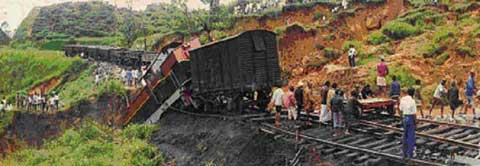
Photo.1 Landslide occurred in Nuwara Eliya in 1992 (HP of NBRO)
(2) Sediment-related disaster in 2003
As mentioned earlier, a large-scale sediment-related disaster occurred in Sri Lanka in 2003. It mainly occurred in the Ratnapura and Kalutara areas in the southwestern part of the country. In the current field survey, two damage sites were investigated in Ratnapura.
(i) Helauda (Photo.2)
Before the disaster in 2003, another sediment-related disaster occurred in this area in 1993, claiming the lives of 50 people. The upstream area is a steep slope with a gradient of about 40°where a collapse occurred and run down to the downstream area. The depth of the collapse appeared to be 2-3 m. The collapse has continued even after 2003 and they said that the latest collapse occurred only recently. All the residents have already relocated and no houses now exist that may be involved in a disaster.
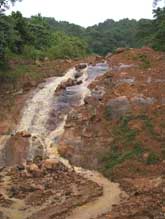
Photo.2 Disaster site at Helauda
(ii) Palawella (Photo.3)
In this area, 58 people were killed in the sediment-related disaster in 2003. It appears that a slope collapse turned into a debris flow. All the houses existed in this area have already relocated. According to the hearing, the earth and stones fluidized by the debris flow reached up to a small hill on the opposite side of the river several hundred meters away, carrying people with it. In fact, trees were partly missing at the lower part of the hill when I visited the area.
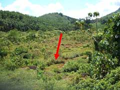
Photo.3 Disaster site at Palawella (Scars of collapse are rather invisible now because of vegetation recovery)
These two areas have some similarities: a) A collapse type debris flow occurred; b) People used to live in a house located in the dangerous area on the hillside of a mountain, because of convenience for their agriculture such as rubber or tea cultivation; c) A large number of people were involved in the disaster, but all the remained houses are now relocated, leaving none at the disaster site.
3. Disaster prevention system in Sri Lanka
Prompted by the Indian Ocean tsunami disaster in 2004, the Sri Lankan government decided to improve its disaster prevention capacity and is currently establishing an organizational structure that can advance the countrys disaster prevention measures drastically. Concerning sabo, there are no responsible administrative-level organizations at this moment. The only relevant entity is NBRO which is in charge of the research aspect of sediment-related disasters. Therefore, what is needed hereafter is to promote the establishment of a system that can work for the implementation of sabo projects.
National Building Research Organization (NBRO)
With the support from the United Nations Development Programme (UNDP), the NBRO has been preparing landslide hazard maps (1/50,000 and 1/10,000) actively since 1990s and they are scheduled to complete in 2007 (Fig.3). However, because NBRO is a research institution, it appears that those maps are distributed to agencies and local governments only, and not distributed to the local people level. Therefore, what must be attempted hereafter are to establish and strengthen a sabo-related administrative structure; to share sabo technologies and information accumulated by NBRO and other organizations with the general public; and to incorporate them into the construction works and nonstructural measures to be taken on the field level.
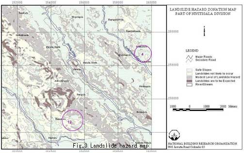
Fig.3 Landslide hazard map
<References>
1) Survey Report on the 2003 Sri Lanka Flood Disaster: Survey Group on 2003 Sri Lanka Flood Disaster, Committee on Hydroscience and Hydraulic Engineering of JSCE, and Foundation of River & Watershed Environment Management, Sep. 2004.