Indonesia
STRENGTHENING AND SUSTAINABILITY OF THE COMMUNITY BASED DISASTER MANAGEMENT
Lessons learned from Indonesia
Dorothea Agnes Rampisela
ABSTRACT
In the past, the support for disaster prevention was addressed principally by reinforcing physical structures. But recently, a combined approach that incorporates nonphysical measures has gained greater importance. The role of community based disaster management has been recognized as integral to disaster management. Specifically, the possibilities for community participation in mitigation and prevention of disasters are also increasing.
The effective application of these approaches for disaster management depends greatly upon their appropriateness for the social and economic context in which they are applied. This paper described the emerging role of community participation in mitigation and preparedness phases of disaster management which focuses on activities by local communities and the roles of government and scientist on strengthening their capacity to deal with natural disasters and highlight the emerging challenges in making implementation of these approaches effective.
While it is true that Community Based Disaster Management largely calls for the community’s own initiatives, it appears that in order to achieve its sustainability, it must involve the government at all levels. This discussion is to focus on how Community Based Disaster Management can be institutionalized at the policy level in Indonesian administrative system.
1. Back ground
The Bawakaraeng mountain collapsed disaster occurred on March 26, 2004 with 33 missing or dead and other physical damages on housing, school, paddy fields, and plantations. The mountain’s collapse caused unstable deposit material of 200000000m3 which covers the upstream river to about 6 km in length which is still potentially dangerous to the people living along the riverside about 35 km downstream due to the possibility of huge amount of debris flow. The local community have almost no experience in facing the debris flow disaster. The debris flow is estimated to endanger about 600 households and give indirect impact to the community living along the riverside. It is important to inform the community regarding the threats and possibility of sediment related disaster. It is also important to define an effective method in socializing the sediment related disaster information, considering the low level of education and knowledge on sediment related disaster of the local community. They should be informed about the current situation and related disaster.
The warning system should be developed and established. The developed warning system must be socialized and reach all households in the disaster-prone area. It is also important to provide the hazard map.
PhD in Hydrology, Erosion Control Dept, Kyoto Univ 1992. Lecturer at Dept of Soil Science, Faculty of Agriculture and Forestry, Hasanuddin University Makassar Indonesia.
2. Objective:
To identify the important mechanism of sustainable Community Based Disaster Management in reducing risk factors in disaster management and some concrete actions that can be taken to achieve such mechanism through partnership with scientists and government.
3. Overall pictures of Disaster Management System in Indonesia
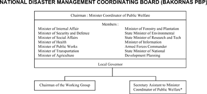
At the national level, BAKORNAS PBP is a non-structural entity designed to promote coordination in managing disasters and displaced persons established in 2001 by Presidential Decree 3-2001 on the establishment of BAKORNAS—The National Coordinating Board for Disaster Management and Displaced Persons.
The BAKORNAS Decree 2-2001 on general guidelines for Disaster and Displaced Persons Management provides broad policies, strategy, and management framework for handling disasters. BAKORNAS answers directly to the President. The secretariat of BAKORNAS PBP is structured under the office of the Vice President, chaired by the Vice President, and managed daily by the Secretary of Vice President. Members of BAKORNAS PBP include the Ministers of Home Affairs, Health and Social Welfare, Public Works, Communication, Energy and Mineral Resources, Manpower and Transmigration, Finance, Forestry, Environment, Army Forces, National Police, Governor of the Disaster Prone Regions, and the Secretary of the Vice President. BAKORNAS is supported with TASK FORCES and EXPERT GROUPS working on different aspects of disaster management.
The primary role of BAKORNAS is to formulate policies, coordinate implementation of activities, and provide guidelines and directives in all phases of disasters management.
The function is to coordinating planning, supervision, monitoring and evaluation of disaster and IDP management; formulating program and guidelines; coordinating the cooperation between sectoral agencies and non-governmental agencies; reporting; coordinating the provision of assistance to victims of disasters; conducting field implementation as necessary; and to implementing activities as directed by the President. Picture 1. shows the organization structure of BAKORNAS
4. Commmunity Level Activities
a. Responds
During or directly after the disaster event, local community , NGOs, local government, Red Cross, SAR teams from several universities and other private sectors came to provide food and help the evacuation of victims. This activities was not organized integrally. Each party tried to make direct contact and give help and donations to the refugees and victims. The subdistrict level of local government tried their best to organize, however there were neither manuals nor guidelines to follow. Central level government official from Ministry of Public Works came to make assessment on the disaster and made a statement on the scale and cause of the caldera’s collapse, reported to the local government at sub-district and district level. Scientists and researchers from related institutions (such as University and assigned JICA experts on Sabo and Forestry) also came to do some preliminary survey on the disaster and reported the results to the Vice Governor.
b. Preparedness
It is estimated by scientist and researchers that the collapsed sediment lied on the river body will flow as debris flow during the rainy season. The following threats are coming and will endanger wider area and communities. Initiatives were taken by the scientist and researcher to make identification of disaster prone community groups. Collaboration with NGO member and community resulted in the preliminary disaster prone community groups map.
• Establishment of Sabo Community Groups The display of debris flow disaster in Japan was a trigger that successfully invoked awareness of people about the following debris flow disaster after the mountain collapsed. After several meetings and discussions held by government agencies collaborating with local government, university and ISDM project of Sabo Technical Center, the community decided to establish SABO Community Group. From initial 10 groups, now the Group has grown to 22 groups, with total members of approximately 820 people. Later on they decided to form a Communication Forum involving the supported NGOs members. The establishment of Sabo Community was announced formally June 2004 at the community meetings with JICA mission team.
• Participatory monitoring system The existence of Sabo Community enabled systematic and organized activities. Related to the disaster preparedness works, participatory monitoring is executed. The monitoring is aimed to provide necessary data for developing warning system and at the same time also aimed to raise the awareness and knowledge of the local community on the threatening debris flow. Daily Monitoring of rainfall and sediment movement were simplified in order to be operated by the local community. Short trainings and operation manual were conducted and prepared by the related institutions and researchers. The monitoring is still continuing for more than one year until now. Monitoring of sediment movement is done using taking pictures digital camera from several points. Active monitoring at several monitoring post are conducted during rainy season.
• Socialization of warning system Socialization of developed warning system is done by training and exercise for representatives of sabo community groups, and notification and announcement at mosques every Friday after praying time. An general simulation on warning system involving all stakeholders was done at the first year memorial ceremony on March 26, 2005. The simulated warning was sent from rainfall rate monitoring station through radio message and kentongan beats, responded by kentongan beats of surrounding households . The radio messages are also relayed to all radio communicators at each villages. When the beats signaled alarm, villagers started to run to the direction of the nearest yellow flags heading to the nearest evacuation spots. They stayed there until the safe signal was sent. During that time the Red Cross volunteers were doing their job helping wounded persons. The demonstration was done at the football ground in the village. All the school children and villagers participate in the demonstration.
• Preparation of disaster prone area map and preliminary hazard map With the help of Participatory Rural Appraisal tools (community mapping etc), preliminary disaster prone area map and lines of evacuation road was determined by the community. Each group prepared their own map. This procedure needs approval and refinement from scientific point of views, however the process helped them to get image and understand the scale and potential danger.
c. Prevention
Community empowerment. These newly-formed sabo community groups need institutional building to strengthen groups collaboration. They are already bound by one purpose of saving life and mitigation of disaster. This spirit should be strengthened and encouraged. During dry season the threats lessen, and therefore some activities are necessary to develop collaboration system and group identity. Each group is encouraged to do some activities. Several activities initiated by groups are water supply system, growing seedlings and construction of monitoring posts. The community is also encouraged to make use of the abundant sand material and change disaster to prosperity. The paving block making program was conducted started by sending 10 villagers to the Makassar city to learn the techniques. Two sets of machine are provided on their proposals. The trained persons back at the community and teach other members how to make paving blocks. The paving blocks produced during the series of trainings are then used to pave the evacuation roads, from housing complex or from rice field to the evacuation spots.
5. Other stakeholders activities
Several activities conducted by related institutions are as follows:
• Training of facilitators
Considering the lack of knowledge and experiences on sediment related disaster of the NGO members and facilitators, several training were conducted. Knowledge on Sabo and sabo works, debris flow mechanism, disaster management, warning system and hazard map preparation
• Workshops and coordination meetings
Workshops and coordination meetings were also arranged by related government offices. Some meetings are integrated but others are still fragmented. The existence of sabo community groups were able to integrate the fragmented activities of several institutions.
• Provision of facilities
Local government provided emergency kits and handy talkie for monitoring posts. One motorcycle also provided for facilitators. Japanese Embassy provided information center equipped with radio broadcasting station and books on disasters and other related topics.
6. Other stakeholders activities
Several obstacles were experienced during the execution of grass root level activities
- Fragmented activities were conducted by independent institutions
- Unclear and inadequate information on cause, effects and procedure of the disaster.
- Unclear Coordination and budgeting procedure
- Lack of knowledge on disaster management of the community and government officials
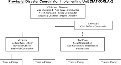
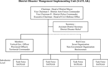
- The coordination function BAKORNAS, SATKORLAK, SATLAK and its task Forces was lacking
- Lack of detailed guidelines and manuals for disaster management. BAKORNAS Decree 2-2001 on general guidelines for Disaster and Internal Displaced Persons Management provides broad policies, strategy, and management framework for handling disasters. However, it has not been accompanied with detailed guidelines for implementing disaster management. Besides that,limited socialization of the Guidelines means that only a few Local Governments can fulfill the functions assigned by the Decree. According to the Decree, Local Governments (SATKORLAK) are required to prepare Guidelines for the implementation of response for managing disasters, coordination of efforts for disaster, reporting, monitoring and supervision
7. Concluding remarks
Community Based Disaster Management are already set-up at the grass root level. Their existences provide effective measure to the preparedness of the community and prevention works. However, the sustainability of the grass root level activities is mainly depend on the institutionalization at the policy level.
- The main idea in Indonesia is connecting the Sabo community groups into the task forces. Trained facilitators should be a member of task forces at local government level.
- BAKORNAS did not effectively function due to its non-structural entity. The problem with this form is that there is no agency or individual working full-time on planning, programming and managing disaster issues, not to mention about significant gaps in staffs capacity for disaster management. It is important for Central Government to improve the authorities, responsibilities and capability of BAKORNAS in managing the disaster problems.
- Preparation, Socialization and dissemination of The Disaster related guidelines are urgently important.
- Disaster related experts education and trainings is the main priority to handle and formation of Experts group
- Data base system and other technical supporting system such as GIS etc are important to be manage for disaster importance.
References:
Brenda Murphy and Holly Dolan, 2003. Social Capital and Disaster Management: Building Community Capacity Community Report.
Ernest Zebrowski, Jr. (1997), Perils of A Restless Planet, Scientific Perspective on Natural Disaster, Cambridge.
Jonatan A. Lassa, 2004. Introduction on Disaster Risk Management (DRM)
Widjono Ngoedijo, 2003. An Overview of Disaster Mitigation in Local Planning and Programming in Decentralized Indonesia. PERFORM PROJECT, INDONESIA.
Zubair Murshed, 2005. Community based disaster management, Asian Disaster Preparedness Center.


| Name of Sabo Community | Leader | Establishment | Location | Number of Members | Nos of HHs in hamlet | Monitoring Post | Nos. of Evacuation station | ||
| hamlet | Village/ward | Sub district | |||||||
| 1. Parangkeke | Suleman | June, 2004 | Panaikang | Bulutana | Tinggimoncong | 43 | 158 | Posko-1 | 1 |
| 2. Bangkeng Sisang | Nurliung C. | June, 2004 | Panaikang | Bulutana | Tinggimoncong | 52 | 158 | Posko-1 | 1 |
| 3. Tobanda | Samuddin | June, 2004 | Panaikang | Bulutana | Tinggimoncong | 27 | 158 | Posko-1 | 1 |
| 4. Janna | Usman | June, 2004 | Bontote’ne | Bulutana | Tinggimoncong | 32 | 43 | Posko-1 | None |
| 5. Batu Menteng | Muhamad Edi | May, 2004 | Bontote’ne | Bulutana | Tinggimoncong | 36 | Not clear | Posko-1 | 1 |
| 6. Bontote’ne | Junaid | June, 2004 | Bontote’ne | Bulutana | Tinggimoncong | 47 | Not clear | Not clear | 1 |
| 7. Tassala | Kahar | June, 2004 | Bawakaraeng | Manimbahoi | Tinggimoncong | 11 | Not clear | Posko-2 | 1 |
| 8. Tumbu Riwata | Alimin | June, 2004 | Bawakaraeng | Manimbahoi | Tinggimoncong | 29 | 117 | Posko-2 | 2 |
| 9. Daraha | M Dg. Nusu | June, 2004 | Nirannuang | Majannang | Tinggimoncong | 33 | 116 | None | 1 |
| 10. Lantebung Putepala | Mudu Gaso | June, 2004 | Nirannuang | Majannang | Tinggimoncong | 28 | 78 | Posko-3 | 1 |
| 11. Biring Tumbua | Muhamad Daud | June, 2004 | Nirannuang | Majannang | Tinggimoncong | 27 | Not clear | Posko-3 | None |
| 12. Liku Labua | Abd. Rajab | June, 2004 | Nirannuang | Majannang | Tinggimoncong | 25 | Not clear | Posko-3 | 1 |
| 13. Bangkeng Popoang | Rahman Talla | June, 2004 | Lombasang | Majannang | Tinggimoncong | 18 | Not clear | Posko-3 | 1 |
| 14. Bulo Karisa | Muhamad | May, 2004 | Sironjong | Majannang | Tinggimoncong | 27 | 82 | Posko-4 | 1 |
| 15. Gamissang | M. Nurdin | May, 2004 | Sironjong | Majannang | Tinggimoncong | 27 | 82 | Posko-4 | 1 |
| 16. Salu | Dg. Labbiri | May, 2004 | Sironjong | Majannang | Tinggimoncong | 27 | 25 | Posko-4 | 1 |
| 17. Bulo | Jamali | June, 2004 | Pangajiang | Parigi | Tinggimoncong | 67 | approx. 300 | Posko-5 | 2 |
| 18. Tanete | Rusmin | June, 2004 | Saluttowa | Parigi | Tinggimoncong | 80 | approx. 220 | Posko-6 | 3 |
| 19. Limbua | Najamuddin Bella | June, 2004 | Saluttowa | Parigi | Tinggimoncong | 80 | ditto | Posko-7 | 2 |
| 20. Poncodde | Dg. Ronrong | June, 2004 | Bangken Parigi | Jonjo | Tinggimoncong | >20 | 32 | Posko-8 | 1 |
| 21. Appokang | Rama Ranca | August, 2004 | Pattene | Tamalate | Manuju | 42 | 280 | Posko-8 | Not clear |
| 22. Borong Sapiria | Dg. Sattu | June, 2004 | Lebong | Lonjoboko | Parangloe | approx. 40 | Not clear | Posko-7 | 1 |
| Total (22 Communities) | - | - | - | - | - | approx. 820 | - | 8 Posko | approx. 24 |
(Quotation literature: International Symposium on Utilization of Disaster Information~Organizing and Sharing Disaster Information in Asian Country~(JSECE Publication No.44), Copyright © The Japan Society of Erosion Control Engineering)