Cases of Disaster
Provision of information for supporting warning and evacuation activities
Mie Prefecture provides useful information for warning and evacuation such as the amount of rainfall to Fujiwara-cho and disaster prevention organizations in areas around the town.
Furthermore, the local government is engaged in providing disaster information under guidance with a definition of the criterion of a debris flow occurring at river basins around Mount Fujiwaradake and on its operating method, by analyzing rainfall at the occurrence of debris flows and debris flow occurrence mechanisms within the basin, and establishing the" Review Committee on Standard Rainfall of Debris Flow Occurrence at River Basins around Mount Fujiwaradake" (Chairman: Takahisa Mizuyama, professor of graduate school, Kyoto University).
Immediate identification of occurrence of debris flows
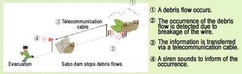
A wire sensor, a vibration sensor, and a monitoring camera are installed upstream at torrents to detect the occurrence of debris flows. If a falling debris flow breaks a wire sensor or debris flow vibration is detected, sirens at dams and in the town sound.
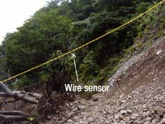
Wire sensor installed upstream at Nishinogaito River.
*)The sensor is colored yellow in the picture so that it can be easily seen.
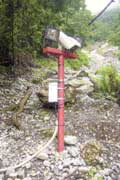
Warning system installed at Kotaki River No.1 Dom.
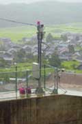
Monitoring camera installed upstream at Nishinogaito River.
Measures against localized rainfall
It often rains only in areas around Mount Fujiwaradake, so a rain gage was installed near the mountain to identify localized rainfall, and provide the information to the municipal government.
Definition of the criterion of debris flow occurrence and provision of information
Based on the recommendations of "Review Committee on Standard Rainfall of Debris Flow Occurrence at River Basins around Mount Fujiwaradake,"
- (1) ten-minute rainfall (in general, hourly rainfall) is used as an indicator for the occurrence of a debris flow, because debris flows occur readily at river basins around the mountain due to heavy rain in a short time.
- (2) An evaluation method, called the tank model method, in addition to rainfall, is used, because debris flows that occurred in the past were strongly affected by not only surface running water but also underground percolating water.
Furthermore, this information was used for the warning and evacuation from August 8 to 9, 2003.
Fujiwara-cho's response to the occurrence of disasters on August 8-9
| August 8 | |
|---|---|
| 7:40 | Radio-broadcast: With the approach of a typhoon, weather information was reported. The municipal government notified residents that they should be ready for an evacuation recommendation. |
| 10:00 | A meeting on preventive measures against debris flows was held. |
| 14:55 | Radio-broadcast: Weather information was reported to Sakamoto and Ohgaito areas. |
| 15:10 | Radio-broadcast: Voluntary evacuation information was reported to Sakamoto and Ohgaito areas. The Cultural Center and public halls of Sakamoto and Ohgaito areas were opened to residents. |
| 15:50 | Weather information: A heavy rain /flood/high surf alert was issued to northern Mie Prefecture. |
| 15:55 | A disaster countermeasures office was established. |
| 16:00 | Radio-broadcast: Voluntary evacuation information was reported to Sakamoto and Ohgaito areas. It was reported that evacuation centers were opened. |
| 16:23 | Radio-broadcast: It was reported that the warning had been issued at 15:50. |
| 16:55 | Radio-broadcast: Weather information was reported. |
| 17:00 | Weather information:A heavy rain /flood/storm wind/high surf alert was issued to northern Mie Prefecture. |
| 17:00 18:02 19:55 |
Radio-broadcast: Voluntary evacuation information was reported to Sakamoto and Ohgaito areas. The Cultural Center and public halls of Sakamoto and Ohgaito areas were opened to residents. |
| 20:15 | Radio-broadcast: Evacuation information was reported. |
| 20:30 | Radio-broadcast: It was reported that an evacuation recommendation might be declared for Sakamoto and Ohgaito areas at midnight. |
| 21:40 | Radio-broadcast: Weather information was reported. |
| 22:32 | A wire sensor was broken for the first time. (Kotaki River and Nishinogaito River) |
| 22:55 | Radio-broadcast: The declaration of evacuation recommendation was reported. |
| 22:57 | A wire sensor was broken for the second time. (Nishinogaito River) |
| 23:22 | It was reported that a debris flow had stopped at Nishinogaito River No.2 Dam. |
| 23:30 | It was reported that the water level at Kotaki River had increased. |
| 23:40 | It was reported that a stand was caught at a temporary bridge at Kotaki River. |
| August 9 | |
| 0:26 | A wire sensor was broken for the third time. (Nishinogaito River) |
| 6:30 | It was reported that riverbed water was changing to a river in Nishinogaito. |
| 9:27 | It was reported that debris flows overflowing at Kotaki River were deposited. |
| 10:30 | Weather information: Alert was downgraded to a warning. |
| 10:53 | It was reported that the water level was decreased. |
| 12:00 | The evacuation recommendation was removed. |