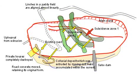
Cases of Disaster
Landslide Mechanism
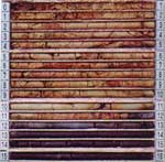
The geology around Taniya Area consists of an alternate layer of mudstone and sandstone (including tuff) belonging to the Otogawa formation during the Miocene, Neogene. The geological structure strikes to the direction of almost northeast to southwest and is inclined to the east at an angle of 5 to 15°. The landslide slope is a moderate dip slope inclined to the downstream side of Konuma River at an angle of 5 to 15°, in which the tuffaceous sandstone layer (growing cracks and coloring brown by oxidation) caused a landslide this time. On the other hand, in January, July and November of 2002, there was an amount of precipitation of 400 to 500 mm substantially exceeding the amount in a normal year. This continuous rainfall in large quantity can be considered to be a contributor to the occurrence of the landslide.
Core with a clear boundary of tone colors (BV-8)