Cases of Disaster
Sri Lanka
Landslide hazard prevention in Sri Lanka
Dr. Ryosuke Tsunaki
Sabo and Landslide Technical center, Japan
- 1. Introduction
- The author was dispatched to Sri Lanka as a short-term expert of JICA from April 24 to May 7, 2011. The purpose of this dispatch was to provide advice on investigations of flood and landslide disasters that occurred in the eastern part of Sri Lanka in January 2011 and to reduce the amount of damage caused by the disaster and promote the Disaster Management Capacity Enhancement Project Adaptable to Climate Change that JICA has been implementing in Sri Lanka.
- 2. Disaster prevention system in Sri Lanka
- The agency that manages disaster prevention in Sri Lanka is the Disaster Management Centre (DMC) in the Ministry of Disaster Management. Japanese experts have been dispatched to DMC to implement the Disaster Management Capacity Enhancement Project Adaptable to Climate Change since last year. Usual operations of DMC include sharing information and coordinating activities among organizations involved in disaster prevention, increasing the local residents’ awareness of disasters, building and improving disaster prevention communities, and conducting evacuation drills with communities. DMC is also responding to emergencies and assisting in the distribution of relief aid in the event of disasters by sending warnings, and gathering and reporting information through local organizations. Also, DMC is identifying the status of damage and recovery status of damaged infrastructures after disasters and compiling the information in reports.
Other main agencies involved in this project (disaster prevention) are as follows:(1) National Building Research Organization (NBRO): NBRO is creating hazard maps and planning landslide hazard prevention in the same ministry (with the main focus on ten districts with frequent landslide hazards). NBRO is also conducting investigations and construction work.
(2) Department of Meteorology: The Department of Meteorology conducts meteorological observations (not including hydrological observations), distributes observed data, and issues warnings of bad weather (including heavy rain) and tsunamis, but its operations do not include issuing warnings on individual disasters such as floods and landslides.
(3) Department of Irrigation: Operations of the Department of Irrigation include management of dams and precipitation observations at 20 locations in four major river basins, and the department issues warnings at the river basins.
- 3. Conditions at some of the landslide sites
- The author visited more than ten sites during his stay in Sri Lanka. Conditions at two of the sites are described below.
- 3.1 Mahawewa area
-
This is one of the model sites where DMC is conducting observations with extensometers and boring investigations in the Nuwara Eliya District with the cooperation of experts from Japan. A landslide here damaged 16 houses, and the width of the landslide is estimated to reach about 300 meters at most with a length of about 700 to 800 meters. The top section is flat, and ponds and swamps spread in some sections (Photo 1). Between the top section and the central section is a slope with an angle of about 15 to 20 degrees. The lower section is a slope with an angle of 20 to 25 degrees, and landslide masses are separated into two branches. The width of the right branch looking from the top section of the slope (Photos 2 and 3) is about 70 meters, and the soil mass is relatively disturbed; thus, the traveling speed of this slope is assumed to be relatively fast. An elementary school and junior high school are located at the side of the landslide, only a few tens of meters from the edge of this branch (the buildings toward the back of Photo 2). Despite the height difference between the landslide mass and the schools, certain measures must be implemented at this site. On the other hand, the branched mass on the left seemed to have barely moved in this landslide incident. A significant movement of soil mass was recorded in 2007 at this section, and 90 houses were reportedly relocated.
Photo 4 shows the extensometers installed near the scarp at the top (the observation is now discontinued). The general trend shown in the observation data of five units including these extensometers indicates that two units at the top recorded tensions of about 20 centimeters from late December to early January. On the other hand, three extensometers installed at the center recorded similar tensions from late November to mid- to late-December. These observations indicate the condition of the landslide in this section, in which the shift in the lower section triggered a shift in the top section. However, continuous observations and detailed on-site investigations are required to identify whether a similar landslide would occur at the site in the future.
- 3.2 Bodhikotuaa area
-
The Bodhikotuaa area is located in the Metale District located about 20 kilometers north from the city of Kandy. The landslide completely destroyed four houses and partially damaged two (Photo 5). The width is estimated to be about 150 meters at the edge at the widest point and the length about 80 to 100 meters. Houses are located side by side at the top section located directly below the road, and a wooded area spreads over the lower slope, which is a short slope (15 to 20 meters) with an angle of about 20 degrees. About 20 meters from the lower section of the short slope is an area used for rice paddies which extend to the small stream at the edge of the slope with an angle of about 10 to 15 degrees. An irrigation channel was built at the border between the wooded area and the rice paddies, and it was also destroyed in the landslide.
The height difference at the scarp at the top is only about three meters at most, but the landslide reportedly kept moving for two to three weeks. Thus, residents were able to evacuate, and fortunately no one was hurt although six houses were destroyed.

Photo 1. Flat area at the top section of the Mahawewa area (ponds occasionally form)
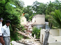
Photo 2. Right branch looking from the top of the slope (elementary school and junior high school are seen beyond the disturbed soil mass)
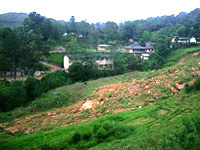
Photo 3. Extensometer near the top
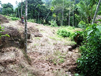
Photo 4. Destroyed house in the Bodhikotuaa area
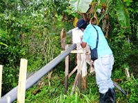
Photo 5. Condition at the edge