Cases of Disaster
【Immediate Report】Sediment-related disasters that struck Indonesia in January 2006
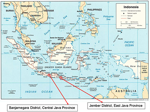
- Banjir bandang disaster (Jember District, East Java Province)
- Mudflow disaster (Banjarnegara District, Central Java Province)
ISDM Project Urgent Survey Team of Japanese Experts
Fumihito Watanabe (JICA long-term expert: chief advisor)
Masato Jogasaki (JICA long-term expert: sediment control planning)
Hiroshi Nakanishi (JICA long-term expert: disaster prevention information)
Yoshihiro Ueda (JICA long-term expert: sediment-related disaster prevention engineering)
1. Introduction
Early in the New Year 2006, many sediment-related disasters hit Indonesia. In the wee hours of January 2, a massive banjir bandang occurred in Jember District, East Java Province of Java Island, which rendered 103 people dead or missing (hereafter Jember disaster). Before dawn of January 4, a large-scale landslide-like collapse occurred in Banjarnegara District, Central Java Province of Java Island, which developed into a sediment disaster that left 85 people dead or missing (hereafter Banjarnegara disaster).
In response to the request for an urgent survey from the Director General of Water Resources Development and Head of Agency for Research and Development, Ministry of Public Works of Indonesia, the ISDM Project has joined forces with staff from the Sabo Technical Center (STC), its counterpart, to conduct a survey on the Jember disaster (first investigation between January 4 and 7, second between January 17 and 20) and the Banjarnegara disaster (on January 10)
(Figure 1: Disaster locations).
The following is to report the results of the survey.
2. Jember disaster
2.1 Overview of the basin
Jember District is located about 400 km (about five hours by car) east-southeast from Surabaya, the capital of East Java Province. The recent disaster occurred along Denoyo River, a sub-tributary of the Bedadung River System managed by Jember District, and Putih River, its left bank tributary
(Figure 2: Basin outline map).
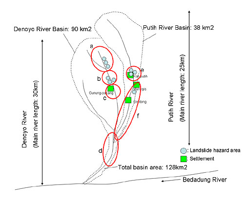
Denoyo River has a main river length of about 30 km and a basin area of about 128 km2 that includes the left bank tributary Putih River, which has a main river length of about 25 km and a basin area of about 38 km2. The average bed slopes of Denoyo and Putih Rivers are about 1/25 and 1/20 respectively.
Both the Denoyo and Putih River Basins originate from the mountain system of an active volcano Mr. Argopro (3,088 m above sea level) and the upper reaches of the two basins are covered with thick layers of volcanic products.
In addition, the two basins have forests covering their headwater areas, the low-lying areas along the rivers used as rubber plantations and the slopes on the banks up to a considerably high level are used to grow commercial crops including coffee beans. From the vicinity of the confluence of Putih and Denoyo Rivers (about 100 m above sea level) downstream has comparatively gentle terrain and is used as settlements and paddy fields to show typical farm village scenery of Indonesia.
2.2 Banjir bandang situation
- (1) Description of damage
-
The general damage caused by the Jember disaster is as follows (as of January 6):
-
Number of people dead/missing: 109 (77 dead, 32 missing)
*Most of the human damage incurred in Kali-putih settlement uppermost stream of Putih River. - Number of houses affected: about 581
- Agricultural land affected: about 370 ha of paddy fields damaged by sediment flood
- Number of irrigation facilities (intake weirs) damaged: 11 (irrigated area: 900 ha)
-
Number of people dead/missing: 109 (77 dead, 32 missing)
- (2) Number of banjir bandang incidents
- Based on the interviews with the local people, banjir bandang were found to have occurred in the Denoyo and Putih Basins almost at the same times: first around 4:00 pm on January 1, second around 6:00 pm on the same day and third around 1:00 am on the next day. Of these, the third one was the biggest, which caused most of the human damage.
- (3) Precipitation
-
Regarding the precipitation before and after the disaster, the following daily precipitation data are available for the upstream area of Jempo River (sub-tributary of the Bedadung River System), which is next to the east side of the Denoyo and Putih Basins (Table 1: Precipitation).
*) The precipitation data have been recorded by the manager of the plantation upstream of the Jempo River Basin with a simple rain gauge. However, the actual rainfall is believed to have been heavier than shown above because the collecting measure had a hole in it.
Table 1: Precipitation Year/Month/Day Daily precipitation (mm) 2005 December 27 7 mm 28 37 mm 29 8 mm 30 27 mm 31 226 mm 2006 January 1 212 mm 2 10 mm 3 5 mm
2.3 Devastation of basins
- (1) Denoyo River Basin
-
1) Situation of the upstream area (Figure 2: Basin outline map a)
(i) Description of landslide on the left bank tributary
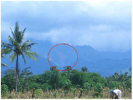
Along the left bank tributary in the headwater area of Denoyo River (about 11 km upstream of the confluence with Putih River, about 700 m above sea level), three massive landslide-like collapses occurred, which can be observed from the Jember city area down the stream (Photo 1: Distant view of landslide hazard area, Photos 2.1 and 2.2: Near view of landslide hazard area).
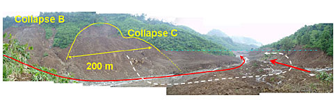
The scales of the collapses, designated A, B and C from upstream, are as shown below:Table 2: Description of collapses Collapse Width (m) Length (m) Depth (m) Collapsed soil quantity (m3) Collapse A About 200 About 200 About 30 About 1,000,000 Collapse B About 300 About 200 About 30 About 1,500,000 Collapse C About 200 About 200 About 30 About 600,000 The collapsed soil became a mudflow, which went over the ridge (about 30 m) on the opposite bank, flowed down along the stream and ran on the opposite bank of the mainstream again to deposit (about 1,600,000 m3). This area along the riverbed looks like a sea of mud and still contains a large amount of moisture after two weeks of the occurrence of the disaster, which suggests that earth and sand containing a large volume of water became muddy and flowed down to deposit at the time of the disaster. In addition, a large amount of collapsed soil still remains on the slopes of the landslide hazard area and has a potential of secondary movement.
(ii) Situation of the upper mainstream
Along the mainstream that joins with the left bank tributary that suffered the landslide-like collapses as described in (i) at immediate downstream, a debris flow containing boulders (1-2 m) occurred and caused sedimentation. However, the riverbed material, flood marks along the river, volume of sedimentation, etc. show a clear difference from the situation of the left bank tributary described in (i) and of the downstream area after the confluence with the stream that suffered the landslide mentioned above, which clearly indicates that the banjir bandang in question did not originate in the headwater area of the mainstream (Photo 3: Headwater area of the mainstream of Denoyo River)
2) Situation of the downstream of the landslide hazard area (section of about 2 km down to Gunun-pasang settlement) (Figure 2: Basin outline map b)
This section of the channel showed mudflow marks of an average depth of a few dozen cm stretching over 150-200 m. Although collapses of various scales occurred on either bank in this section, the appearance of the collapsed soil, etc. suggested that this area was unlikely to have directly caused the recent banjir bandang (Photo 4: Mudflow marks along Denoyo River).
3) Situation around Gunung-pasang settlement (Figure 2: Basin outline map c)
In Gunung-pasang, which is the settlement located uppermost stream in the Denoyo River Basin, 13 people were left dead or missing and most of the human damage was caused by the two landslide-like collapses (deep-seated slope failure of talus accumulation) that occurred on the mountain slope behind the settlement and the slope on the opposite side of Denoyo River. The local people said that due to the swelling of Denoyo River, they were temporarily evacuated to the place where the collapses mentioned above occurred and caused human damage.4) Situation of the downstream flooded area (downstream of the confluence with Putih River (Figure 2: Basin outline map d)
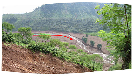
The mudflow from the upstream of Denoyo River joins with the mudflow from Putih River and rushes into the flat ground downstream to flow further down while flooding the paddy fields by the river. In a bent section, a massive overflow of water towards the outer bay apparently became high in sediment concentration and ran through the Jember city area into the mainstream of Bedadung River.
In the section, partial aggradation of riverbed is observed but major erosion is found in the sides of the water colliding front.
The flooded area has sedimentation of muddy fine-grained soil of up to 50-100 cm thick, which indicates that water with considerably high concentration of sediment overflowed (Photo 5: Flood situation of downstream bent section).
- (2) Putih River Basin
-
The field reconnaissance team could only reach up to the immediate downstream of Kali-putih (the settlement uppermost stream of Putih River), which had the biggest human damage in the recent disaster, due to severed roads. For this reason, the situation of the headwater area is unknown and the cause of the recent banjir bandang is yet to be found.
The following sections are to report the situation of the area downstream of Kali-putih settlement, which was observed in the field reconnaissance.
1) Situation around Kali-putih settlement (about 11 km upstream from the confluence with Denoyo River) (Figure2: Basin outline map e)
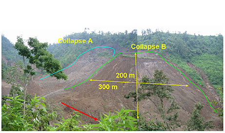
In the vicinity of Kali-putih settlement, Putih River has become a vast sea of mud (about 1.5 km along and 350 m across the stream and about 2-5 m in depth) and sedimentation of mud still containing a large amount of moisture remains as of the time of the survey (January 18). On the mountain slope in the surrounding area, major collapses were observed: one on the right bank and two on the left bank (Photo 6.1 Collapses and sediment flood near Kali-putih, Photo 6.2: Collapse downstream on the left bank).
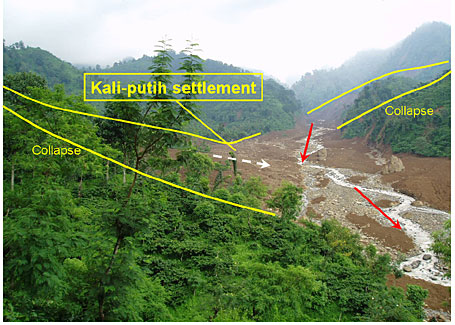
The collapse found upstream on the left bank starts near the ridge (about 1,200 m above sea level) and is massive in scale with about 200 m in width, 300 m in length and 50 m in depth, reaching the bottom of the river (about 400 m above sea level). The amount of collapsed soil is estimated to reach about 1,500,000 m3. Traces are found of the fallen earth and sand running on the opposite (right) bank for about 40 m, which points to a possibility that the collapsed soil temporarily blocked the mainstream of Putih River (Photo 6.3: Landslide hazard area upstream on the left bank).
The collapse downstream on the left bank is about 120 m in width, 150 m in length and 30 m in depth with the amount of collapsed soil assumed to be about 300,000 m3 and the traces suggest that the collapse occurred near the ridge (about 900 m above sea level) and was immediately fluidized to flow down.
Traces of sediment discharge caused by a large-scale collapse were also observed from the right bank, where Kali-putih settlement was located, but the situation above that point could not be confirmed. In agreement with local peoples comment that All of Kali-putih settlement has been buried under the sea of mud, the sight was terrific enough to suggest the fierceness of the sediment disaster that hit the settlement.
The collapses around this area appear to have had significant effects on the generation of the recent banjir bandang, judging from how the collapsed soil turned into mudflows and reached the river.
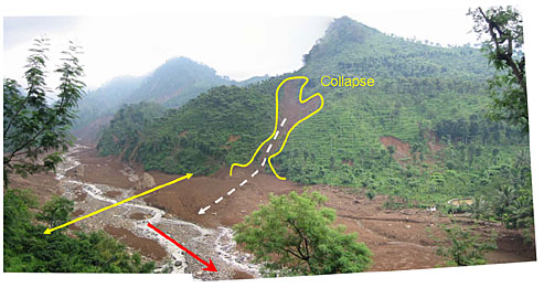
2) Situation of downstream of Kali-putih settlement (section of about 9 km to the confluence with Denoyo River) (Figure 2: Basin outline map f)
The average bed slope of the section in question is about 1/15 and marks of a mudflow of about 150-200 m wide are found along the river, indicating that the banjir bandang that occurred in an upstream area flowed into this district.
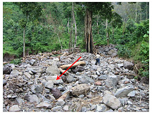
The mudflow caused many boulders (2-3 m) to deposit in comparatively gently sloped parts of the section in question and ran straight through bent sections to flood the houses and fields along the river, which shows that the recent banjir bandang had high concentration of sediment containing many boulders (Photo 7: Deposition of boulders).
In the vicinity of the confluence with Denoyo River, overflows are observed along the river, which is surpassed by the erosion of the water colliding front and banks, and the discharge is considerably small.
Marks show that driftwood logs that are apparently rubber trees (5-10 m long) got stuck at a bridge in an early phase of the flood and caused an overflow but the banjir bandang that devastated the region does not contain such large natural wood.
2.4 Observations about banjir bandang disaster
- (1) Study of peak discharge
-
Based on the traces of floods and flows of mud from Denoyo and Putih Rivers, the peak discharges are estimated to be 2,700 m3/s for Denoyo River and 1,000 m3/s for Putih River.
The above study shows approximate estimates based only on rough investigation of traces but floods with considerably large peak discharges doubtless hit the downstream areas. Study based on more detailed investigation should be necessary. - (2) Cause and mechanism of generation of banjir bandang
-
In the field reconnaissance, collapses that apparently triggered the banjir bandang in Denoyo River were observed. Regarding Putih River, however, the large-scale collapses around Kali-putih settlement were observed but the headwater area upstream could not be investigated and the cause of the flood is still unknown.
In the recent disaster, three banjir bandang occurred in each basin and the collapses observed in the field reconnaissance appear to have had major effects on the generation of the floods and the flowing down of the discharges. However, no clear evidence of the formation of large-scale landslide dams is yet to be found and the mechanism of how floods develop into deluges with such large amounts of discharge in the downstream area is unclear. - (3) Human damage
-
The recent Jember disaster left more than 100 people dead or missing, most of which was caused by the failure of soil according to the local people and disaster victims and the banjir bandang themselves do not seem to be the major cause of the human damage.
As far as the recent disasters are concerned, there was quite a long rain before the occurrence and the local people seem to have expected swelling of rivers based on their past experience. Accordingly, people in the settlements took shelter on high ground such as back mountains about one day before, when banjir bandang struck. Judging from the scope and degree of damage to houses, much more victims would probably have been caused by the banjir bandang if they had directly hit the residents before they evacuated.
3. Banjarnegara disaster
Banjarnegara District is located about 50 km west of the Dieng Plateau, a tourist site in Central Java Province. Before dawn of January 4, a massive collapse occurred on a mountain slope, which led to a disaster that left 85 people dead or missing and 140 houses completely destroyed.
Immediately after the occurrence, the disaster was widely covered by the media including newspapers and broadcasters as tanah longsor (landslide in English). On the evening of January 4, information about the disaster was provided by the Japanese Embassy in Indonesia and a survey for investigating the actual situation was requested by Mr. Siswoko, the Director General of Water Resources Development of the Ministry of Public Works of Indonesia, which urged the ISDM Project to conduct a field investigation on January 10.
3.1 Situations in the surrounding areas
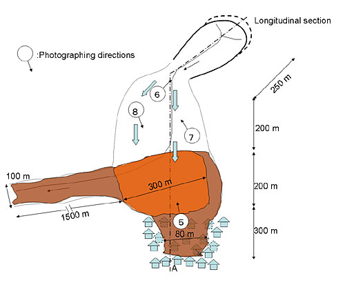
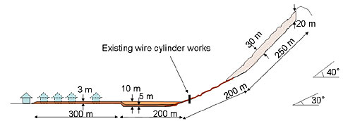
Because the day of the investigation was immediately after the completion of the tracing of missing people, the disaster-stricken region was off-limits and the investigation was conducted under the lead of the military personnel in charge. The situations around the disaster source is described in Photo 8: Disaster source, Figure 3.1: Schematic illustration and Figure 3.2: Longitudinal profile.
The local people say that the stream that caused the collapse did not present clear trough topography before the disaster and appeared as no more than a small depression in consecutive slopes. The consecutive slopes are covered with natural trees of 2-3 m in diameter and 30-40 m in height and the slopes below are generally terraced fields formed into tiers of level planes, where coffee beans, bananas, cassava, etc. are grown. The land use is typical agroforestry. The stream in question has a very small basin with a catchment area of about 10 ha.
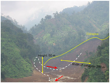
3.2 Landslide hazard area (Photo 9)
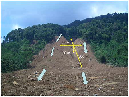
The collapse occurred near the ridge of the consecutive slopes mentioned above (about 400-450 m above the flat area affected). The amount of collapsed soil is bout 500,000 m3.
To the east of the landslide hazard area was observed a talus and the vicinity of the ridge above had a small amount of weathered soil deposited. The inclination of the slope made by the collapse is about 40 degrees and the foundation rock was exposed, which suggests that the collapse in question was a mass of soil thickly deposited on the slope that slid down at once from the foundation rock.
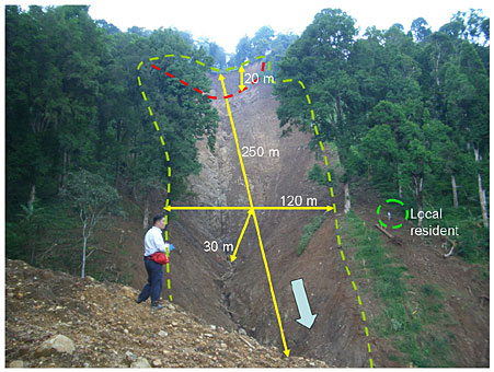
3.3 Situation along the stream (Photo 10)
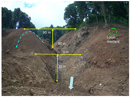
The area along the stream that is downstream of the landslide hazard area is significantly corroded from immediately under the collapsed part all the way to the flat area right below the slopes (30 m on average). In addition, there are marks of soil swept from upstream running on the ridge (about 60 m above the valley floor) on the right bank of the stream, which shows the fierceness of the flow of soil.
3.4 Soil turned mudflow (Photo 11)
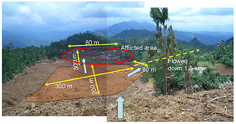
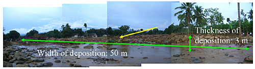
The collapsed/scoured soil that slid down the slopes turned into a mudflow, which ran straight through the comparatively gentle depression (paddy fields before the disaster) right below the slopes, ran on the flat in a settlement on the high ground about 10 m above the level of the depression and destroyed the settlement at one blow. The soil that became a mudflow also flowed down about 1.5 km in the direction of the downstream river to accumulate on the paddy fields on both sides.
3.5 Mechanism of sediment movement
A local resident who suffered the disaster says that a rumbling sound was heard around 1:00 am on January 4, followed by a piercing sound around 3:00 am, and some residents evacuated or started preparations for evacuation. However, there was no sign of crisis in the next couple of hours and people came back home, when, at around 4:30 am, a massive collapse occurred.
The situation of the upstream area after the collapse and the traces along the channel immediately below, etc. indicate that the major damage to the settlement was caused by the fall of the collapsed soil from upstream. Although what the possibly predictive sounds heard by the resident were is not known, small disintegrations occurred at the lower part of slope when the sounds were heard and their effects rendered the clod deposited on the upper part of the slope unstable and led to the collapse at one time.
4. Conclusion
As with every year, Java Island entered the rainy season towards the end of last November and had generally one or two hours of daily rainfall since the middle of December. Compared with the rainy season of the last couple of years, both the frequency and amount of rain were somewhat higher and, since the end of December, the precipitation was even steadier and continuous everyday.
Sediment-related disasters as the recent ones could occur anywhere, given the topographic and geologic conditions of Indonesia. Banjir bandang as in the Jember disaster also struck many places including Lombok Island, Flores Island, Situbondo near Surabaya, etc. in January alone and caused significant human and property damage to people of Indonesia. Banjir bandang occurred in Mojokerto of East Java Province in 2002, Bahorok in North Sumatra Province in November 2003, and Aceh Province in December 2004, causing victims in hundreds.
Banjir bandang, which is translated into English as flash flood, is an Indonesian phrase consisting of words for flood (banjir) and quick (bandang), hence meaning flood that occurs suddenly and used in the media as well. The general population seems to understand it as a form of flood, as the word banjir implies. In fact, banjir bandang are often sediment disasters that occur in mountain terrains and measures to be taken should differ in both structural and non-structural terms but investigations of actual conditions or their causes or mechanisms from the viewpoint of sediment-related disaster have not been carried out so far in Indonesia.
Regarding the Banjarnegara disaster, it was first reported as tanah longsor (landslide). The fact is that the phenomenon that directly caused the disaster was a mudflow, although large-scale slope failures did occur. As with banjir bandang, almost no technical analysis on the mechanism of the disaster has been conducted. As a global trend, sediment-related disasters such as debris floods and mudflows all seem to be classified as landslides but they are totally different in reality and approaches to them should completely differ from the perspective of disaster contingency planning. In Indonesia as well, any sediment-related disaster is categorized as tanah longsor (landslide) and investigations to find out their actual conditions and behavioral mechanisms have hardly been conducted. Adequate investigation of actual conditions of and study of measures for sediment-related disasters are desired in the future.
In the aftermath of the two recent disasters described earlier, emergency aid was given by Japan. As of two weeks after the disaster, when the residents of the afflicted areas are beginning to regain their composure after the confusion present at one point, we saw aid supplies from Japan on site for the first time. Urgent and appropriate aid and response based on pertinent disaster information will probably gain importance in Japans future global cooperation.
At present, the most popular topic in relation to disasters in Indonesia is the restoration and recovery from the Indian Ocean tsunami disaster that occurred in December 2004. Sediment-related disasters caused by storms, volcanic eruptions, etc., as those that recently occurred are generated every year in some parts of Indonesia. Failure to take adequate measures because of non-occurrence of such sediment disasters for a few years (with many of them probably not recognized as sediment disasters if they do occur) will allow disasters as those that recently struck to occur. In Indonesia, which has a population of more than 200 million, the potential of these types of disasters occurring in the future is believed to be growing even larger.
We are now keenly aware of the importance of continued technical cooperation from the viewpoint of disaster prevention.
On a final note, we would like to convey our appreciation to each of the ISDM Project members for their teamwork and activities that have made it possible to successfully complete the field survey of such an extended area. For reasons such as that the disasters occurred unexpectedly during the year-end and New Year holidays, the investigation was in response to an urgent request and the time spared for the investigation was limited, it was difficult to make an exhaustive report and this is to only provisionally report the result of the study. We would appreciate another opportunity to report on the details.